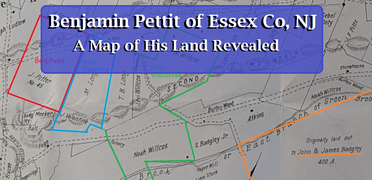
Benjamin Pettit of Essex Co., NJ: An Old Forgotten Land Map Discovered
An unpublished map has been discovered in the New York Library which shows the lands held by Essex County, NJ residents in the year 1845. There is enough evidence in other records to use this map to roughly locate the lands that belonged to Benjamin Pettit as well as some of his known neighbors. A high resolution copy of part of this map, including some added notes, can be seen below (click to enlarge and zoom):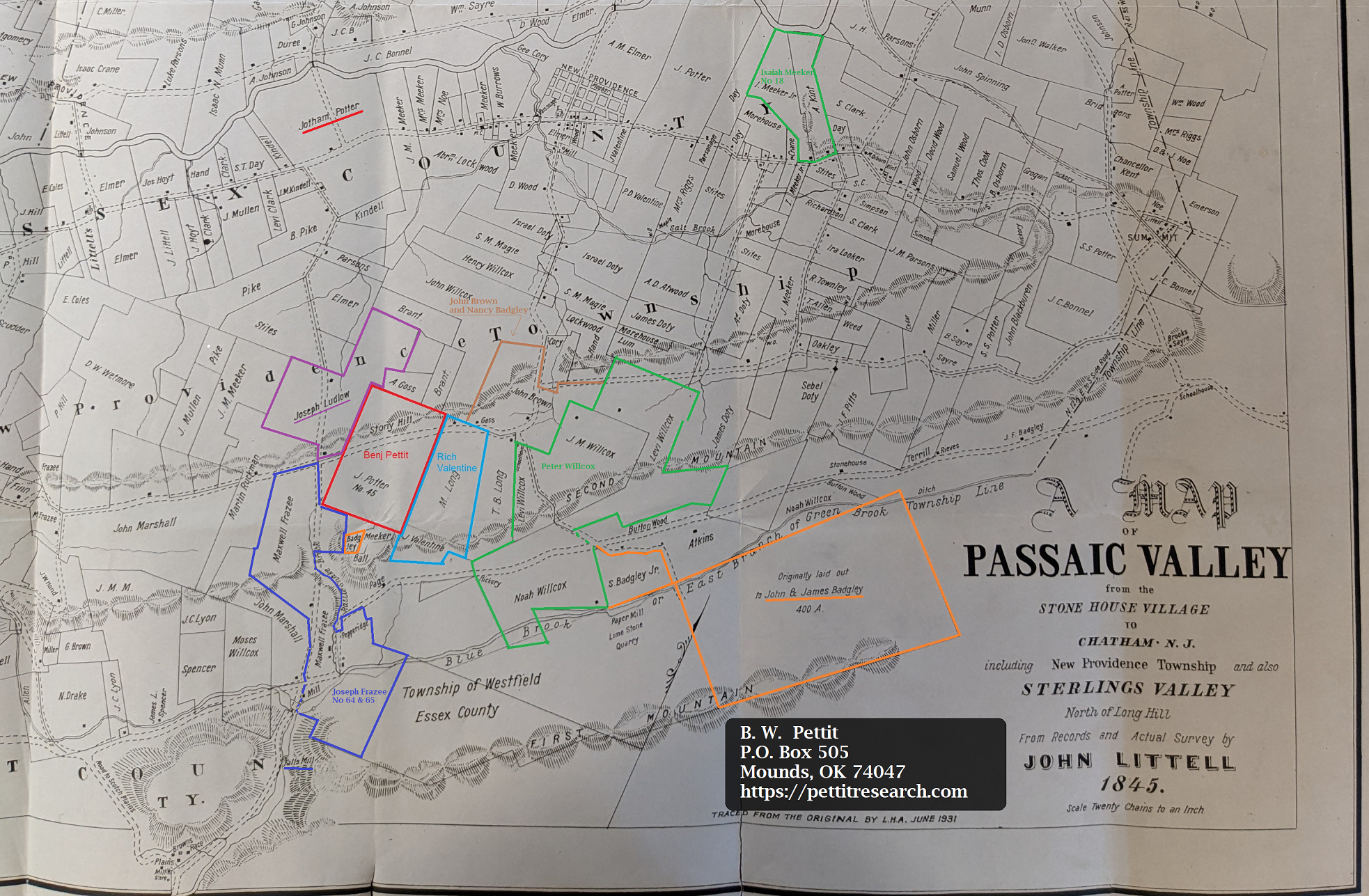
Color coded lot lines for some important lots are shown. Please note that only one of the Benjamin Pettit tracts is shown. The location of the second one (and possibly a third), which adjoined the Passaic River, has not yet been positively determined. It is likely it was the other tract shown belonging to Jotham Potter (underlined in red) but more research will be needed to confirm this. The following subsections of this article will cover the lands and their owners identified in the color coded portions added to the map.
The Benjamin Pettit Tract: Lot #45
The evidence suggests Benjamin Pettit, who was born around 1699, migrated from New Rochelle, NY to Essex County, NJ where he owned 205 acres of land in at least two lots. In his 1852 book, First Settlers of the Passiac Valley, John Littell described the land as follows:
BENJAMIN PETTIT, Esq came from New Rochelle, in the State of New York, to Passaic Valley, and by deed dated 31st December, 1729, purchased 105 acres of land of Jona, Carle; he also purchased in 1737, of the Committee of the Freeholders of Elizabethtown, 100 acres adjoining and lying west of the other tract, and between that and Nathaniel Smith’s tract, and both adjoining the River, which are in possession of his descendants to this day, on which Major Jotham Potter now lives. Benjamin Pettit, Esq. died 30th January, 1771, aged 72 years, and left children, Mary, Abigail and Benjamin Pettit, Jun. (1st Gen.)
…
Phebe Pettit, [Granddaughter of Benjamin above] born 23d December, 1795, and married 6th May 1810, Jotham Potter, son of Amos Potter Esq. On the death of Timothy D. Pettit 2d, in 1842, the name of Pettit became extinct, and the farm is in possession of and owned by Major Jotham Potter, and his wife Phebe Pettit.
These ancient deeds which Mr. Littell referred to are most likely from Essex County deed book A. This deed book covered the early years where men like Benjamin Pettit and Joshua Pettit purchased their land. Sadly this priceless deed book was completely burned up in a fire and no copies are known to exist. The information contained in this valuable source is gone except for shadowy references found in secondary works like John Littell’s book. His book was a compilation of information from various sources including the deed books, family records and the recollections of older local residents. We must keep in mind that a work of this nature will inevitably include some errors but, despite this, it is quite a treasure.
From what Mr. Littell described, Benjamin Pettit owned two tracts and maybe more. We know one of these tracts was lot #45. He did not mention this lot number in the entry for Benjamin describing his lands adjoining the river but it does appear in the section dedicated to his neighbor, Richard Valentine:
Richard Valentine owned Nos. 35 and 44 of the Elizabethtown lots, and lived on No. 44, where Israel B. Long now lives. This lot contained 184 acres, and extended over the Mountain and adjoined Peter Willcox’s tract, lying west of it. It also adjoined the Pettit tract, No. 45, lying west of Valentine’s.
Looking at the map we see Littell marked lot “No. 45” as the lot belonging to “J. Potter”. This J. Potter is the Jotham Potter described by Littell as the husband of Phebe Pettit and the person in possession of this Benjamin Pettit tract in 1852. Oddly enough, Lot #45 does not border the river, the Smith tract or another Pettit tract as noted in the Benjamin Pettit section described elsewhere in Littell’s book. It would seem Benjamin Pettit had multiple tracts and the two previously described were to the north of lot #45 bordering the Passaic River. Nevertheless, Lot #45 is positively identified with him and is also the only lot #45 identified on the map. Lot #45, the Benjamin Pettit land is highlighted in red on the map.
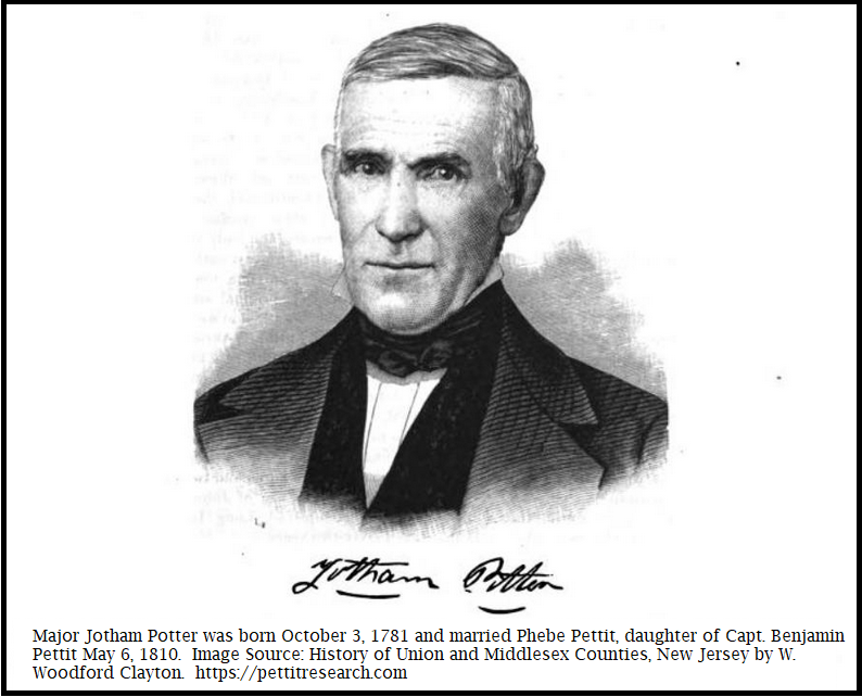
Maj. Jotham Potter husband of Phebe Pettit and inheritor of Benjamin Pettit lands.
Benjamin Pettit’s Essex Co Lot #45 on a Modern Map
The southwest corner of Benjamin Pettit’s land on the 1845 map is south of Stony Hill, north of the Second Mountain and borders the road that is today called Union Ave. The land is cut east/west by Mountain Ave. These points can be placed on a modern map and they line up to produce a fairly accurate overlay. The land Benjamin Pettit owned on Stony Hill was roughly 4.8 million square feet which is approximately 110 acres. This is outlined on the map below:
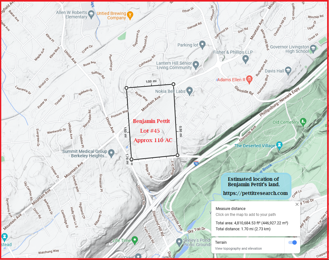
To see the center of this tract on a live google map click here.
In a prior article we traced the estimated location of Joshua Pettit’s Essex County land. The google map at this link shows the driving distance between the two locations was about 4.3 miles.
The Richard Valentine Tract
The Pettit track was said to have been west of the Richard Valentine tract and was where Israel B. Long lived in 1852. In 1845 this land appears to be owned by a Mr. M. Long and possibly a T. B. Long. A small tract belonging to a J. Valentine is also seen adjacent to the south of the Longs. This was probably a residue of the Richard Valentine estate. The map shows the Richard Valentine tract in light blue.
Peter Willcox/Willcocks’ Tract
The Peter Willcox mentioned in the Richard Valentine snippet is described by Littell as follows:
Peter Willcockse came from England and settled between the mountains on a hill known to this day as “Peters’s Hill” on the north side of Blue Brook and a little above Feltville, 6th January 1736-7. There was surveyed to him there, by Joseph Morss, surveyor for the “Elizabethtown Associates” 424 acres of land, lying along the east branch of Green Brook, called Blue Brook; Feltville is situated on this tract.
The Rev. Mr. Hunting, in his history of the Parish of Westfield, says that “this Parish was settled about the year 1720, by the English, and that James Badgley and Peter Willcox located on the mountain before any persons settled below, because it abounded in heavy timber.”
Peter Willcockse married Phebe Badgley, sister of James and John Badgley, lately from Long Island…
Peter Willcox’s large tract was “on the mountain” on Blue Brook and east of the Valentine tract. He was said to have been near the Badgleys. In the 1845 map we see land on the mountain bordering Blue Brook east of the Valentine (Long) tracts belonging to several men bearing the Wilcox family name. They are J. M. Willcox, Levi Willcox and Noah Willcox. Peter Willcox’s estimated tract location is show in green.
The Badlgley Tracts
The Badgleys owned land in the area east of the Willcox land. There were three brothers who came to Essex Co; James, John and George Badgley. Littell said this about the Badgley’s land:
George settled in Elizabethtown. He had a daughter, Nancy, who married John Brown, and removed to Stonyhill. John and James, with their three sisters, came up and settled in the Valley between the 1st and 2nd Mountains, in the year 1736-7. When Joseph Morse, the Elizabethtown Surveyor, was surveying this region, he surveyed for John and James Badgley, a tract of 400 acres of land, between the mountains, lying along Blue Brook, and extending South to the top of the first mountain.
The 1845 map shows a 400 acre tract that is bordered north by Blue Brook and extends south to the top of the First Mountain –just as described. Littell himself labeled this as the Badgley tract. The John Badgley and James Badgley land is show in orange.
John Brown and Nancy Badgley Tract
Littell stated that the Badgleys had at least a minor connection to the Pettit family:
John Brown came from England to Elizabethtown, and married Nancy Badgley, daughter of George Badgley. He removed to Stony Hill, on the Pettit place, and afterwards bought the place where his grandson now lives, where Samuel Johnson formerly lived.
Nancy Badgley married John Brown and lived at the Pettit place on Stony Hill before moving. They didn’t relocate too far. In 1845 their grandson John Brown, inheritor of their home, showed to be living just north and east of the Pettit place. The John Brown and Nancy Badgley land is show in brown.
The Joseph Frazee and Maxwell Frazee Tract
To the south and west of the Pettit tract is the land the belonged to Maxwell Frazee. Joseph Frazee originally owned lots #64 and 65 west. The Frazee tracts’ estimated locations are shown in dark blue.
The Joseph Ludlow Tract
The Pettit’s neighbor to the west was Joseph Ludlow. His land’s estimated location is shown in purple.
Concluding Remarks
The complete 1845 John Littell map contains much more information than has been discussed here. There is also more information on Benjamin Pettit and his neighbors that will need to be exposited in a future article. The nearby Valentine, Willcox, Frazee and Badgley families may be intertwined with the Pettit family in someway or another. If you are a genealogist studying one of these families, please contact me here to discuss or leave a comment on the message board.